
|
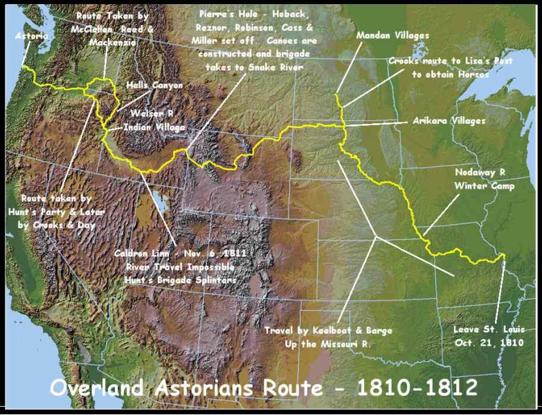
The first written record that I can find of this Snake River/Idaho/Oregon area comes from a Wilson Price Hunt "Astorian" journal. Hunt was the leader of an 1811/12 expedition financed by John Jacob Astor to establish a post at the mouth of the Colombia River. According to Hunt, this journey started along the Missouri River among Native American Arikara villages on 18 July 1811, crossed the North American plains and Rocky Mountains, generally followed the Snake River (below called their "Canoe River") and the Colombia River and arrived at the Pacific ocean on 15 February 1812 -- covering roughly 2000 miles in 212 days (route map). As a part of this expedition, Hunt and some of his original corps1 spent several days on two occasions (26 November and 16-24 December 1811) in the area that the Weiser River flows into the Snake. "...The foothills began to appear on the 26th, spreading along the snowy mountains. We crossed another little stream that flows from the east, like the others...". On November 27th Hunt's group followed the Snake north into what is today called Hells Canyon. On December 6th, after extreme difficulty, he doubled back south to get out of trouble. From his journal: |

| ... "On the 16th we at last left the mountains and
camped on the banks of a river [Weiser] that we had forded on the
26th of the previous month. Thus for twenty days we had worn
ourselves out futilely trying to find a passage along the lower
part of this river [Snake]. On the previous day rain and snow had
fallen. Ice floated on the river and the weather was extremely
cold. Luckily for us, in this district we found a dozen tepees of
the Shoshones2
who had come since we had camped there. They told me that it would
[not?] have been possible for us to find a passage by following
the river [Snake]. This news heightened my anxiety about Mr.
McKenzie and his company. On the 17th I went up the little stream
and camped near a Shoshoni village3. From these Indians I bought a horse and a dog,
and on the 18th I got another horse, some dried fish, a few roots,
and some pounded dried cherries. I spent most of the day getting
information about our route and about the time it would take to
reach the village of Sciatogas. These Indians gave us different
advice; but they did agree in saying that the trail was good, that
it would take us seventeen to twenty-one nights to reach our
destination, and that in the mountains we would be in snow up to
our waists. I offered a gun, some pistols, a horse, etc., to
whoever would serve me as a guide. They all replied that we would
freeze to death and pleaded with me to remain with them during the
winter. "I tried again on the 19th to find a guide. I went to every tepee along the river banks, but without success. I could not get along without one, for that meant running the risk that we would all die. But to remain in this place would be still worse, after having come so far and at such great cost. I ended by telling the Indians that they spoke with forked tongues, that they were lying to me. I accused them of being women; in short, I challenged them with whatever expressions would goad them most. At last, one of them found courage enough to volunteer to be our guide as far as the village of the Sciatogas. According to the report of our Shoshones, these Indians live on the west side of the mountains and own many horses. "Thus, we once more resumed our journey. On the 21st two other Indians joined our guide who led us at once to our Canoe River. We did not find any reed canoes there for the crossing; so we killed two horses and made a canoe with the hide of one of them. In this we got across the river. On the other side I found thirteen of Mr. Crooks' men who told me that since we had left they had not seen either Mr. Crooks or the two men who were with him. When we had all effected a crossing by the 23rd, my people took heart. All of Mr. Crook's men were extremely weak and exhausted, four of them even more than the others. They handed over to me a horse and some goods. When three of them expressed the wish to remain with the Snakes, I gave them a canoe and some supplies. They crossed the river on the following day, and I hoped that they would not be long in finding Mr. Crooks and his party. "My group was now made up of thirty-two white men, a woman4 eight months pregnant, her two children, and three Indians. We had only five puny horses to feed us during our trip over the mountains. On the 24th I [at last] turned away from the Canoe River, remembrance of which will always cause us some moments of unhappiness. We traveled west, crossing hills by a trail that was sometimes level enough, more often irregular, but always good. ...." |
| Hank Corless' "The Weiser Indians: Shoshoni Peacemakers" devotes several pages to generally describe other expedition, fur trapper and Indian activity in the larger western Idaho / eastern Oregon region (1813 to 1860). But specific to the Weiser River / Mann Creek area, by the early 1860s a northern branch of the Oregon Trail had been established crossing the Weiser River, and in 1863 Thomas Cyrus Galloway was maintaining a pony express station at Weiser Bridge5. In the mid-1860s, Galloway homesteaded, under the Homestead Act of 1862, at the mouth of Mann Creek on the Weiser River upstream of Weiser Bridge. In 1869, two upper Mann Creek homesteads were filed, one by my great-great-grandfather John S. Saling and the other by John Collins Anderson6 (ref. this map, select "Parcel Info. Overlays" Anderson, John C.). To encourage other upper Mann Creek homesteaders, John Saling changed his land description from running along the creek to crossing it (map, Saling, John (as of ~1925)) -- and another of my great-great-grandparents, George Adams, filed in 1875 for an adjacent 160 acres (map, Adams, George W. (as of ~1925))7 . From my great-grandmother Catherine Saling Adams' autobiography, here's a snapshot of early Mann Creek settler life and (perhaps) their general attitude toward the Native Americans: |
| ... "In the days before there were reservations for
the Indians, they roamed freely everywhere. They used to
pass our place in droves, single file, usually on foot, but if
anyone was riding it was the men. It was nothing
extraordinary to see fifty to three hundred pass in a day,
especially when they were gathering to go on the warpath. "Many times they camped near us, building their wickups in shady places on Mann Creek. Thus we often had as our nearest neighbors those we so greatly feared. One squaw tried for days to kidnap me. She would spread her blanket down on the ground and pat it with her hand, coaxing me to lie down on it and let her wrap me up. But not I. No, no! "When they went on the warpath, the settlers on Mann Creek and around Weiser built a fort on the old Adams place on Mann Creek8, where the people gathered for safety. They dug a pit about six feet deep and forty feet square, throwing the dirt up along the outer edge to form a higher wall for protection. Bedrooms were dug back in the side walls thus formed and it was understood that the women and children were to go there and hide in case of an attack. A small room of heavy logs with portholes in the sides from which to shoot was built in the center of the fort. It was from there the men were to fight. "Our flag was made by one of the ladies, Mrs. Sol Taylor9, who had the only sewing machine in the county10. As all household possessions had to be hidden in those times in case the Indians should burn out homes, the sewing machine was in the willows down by the creek. The material for the flag had come from Boise. While Mrs. Taylor sewed, I kept watch in all directions that the enemy might not surprise us. Why she should choose me for that responsible task I don't know, as I was only eight years old at the time11. Maybe because I was taking it all so seriously that she felt I would not be lax in my duty. "I remember how foolish I thought it was to make up a flag to fly over the fort. We didn't need it to show us where the fort was and what did Indians care about an American flag. I had been told how they would scalp us and I trembled from fear. Not knowing that anyone could ever tremble from such a cause, I thought I must be getting sick. I had heard the older people talk of having chills in the East. I wondered if that was what was the matter with me. And how I did worry at night for fear the guards might fall asleep and the Indians surprise us. ...." |
| Reference
Corless for a compelling counternarrative of this period of
Weiser Shoshoni history. |
| Eula Newman French12 has compiled two volumes of Mann Creek
history in her Mann
Creek Memoirs. Included therein are tales from the early
Mann Creek settlers and their descendants, genealogy sheets,
passed-down family pictures, church/cemetery records, hand-drawn
maps of early roads and approxmate locations of early land parcels
with ownership. Some of this is researched genealogy and
some is folklore. With Eula's permision I've included on
this site selections from this family folklore and from her
genealogy sheets, giving her and her book full credit as
appropriate. See, for example, folklore pages from the Adams, Anderson, Galloway, Logan, Mann, Pearson, Saling, Stout, Tarter, Walker, and Williamson families.
Additional information on these families may be found on
this site in the Supplemental
sources, notes, documents,... section and/or in the collected
Family Group Sheets. Eula's early Mann Creek settler
information can be found in this Historic Mann/Monroe Creek Maps and Land Owner
Information section. The Ada,
Washington and Adams County Idaho Information page contains an
early Valley census sheet. 1 After separation from the McKenzie, McClellan and Crooks groups at Caldron Linn, ref. "Astorian" journal 2 These were the people currently known as the "Weiser Shoshones" 3 The Indian trail that ran down Mann Creek to the Weiser River, and mentioned by Catherine Saling Adams on this page, surely connected northeast to other Shoshoni areas Indian Valley (>40 mi) and the Payette Lakes (>70 mi), and southeast to the southern Idaho Camas Praries (>100 mi). Ref. this map. Ref. Corless 4 Marie Dorion, ref. https://en.wikipedia.org/wiki/Marie_Aioe_Dorion 5 Weiser Bridge was near the Weiser confluence with the Snake on the northern-most branch of the Oregon Trail between Boise City and Olds Ferry (first operational in 1863 at Farewell Bend). Ref. Library of Congress 1864 George Woodman "Map of the mining sections of Idaho & Oregon embracing the gold and silver mines of Boise & Owyhee" 6 An uncle of my great-great-grandmother Margaret Ellen Anderson. John Anderson moved his family north to Indian Valley in 1875 7 See Historic Mann/Monroe Creek Land Owner Information for a Eula Newman French list of Mann/Monroe Creek homesteaders and homestead locations 8 Ref. Corless, p. 101 9 Née Mary Jane Sater 10 At that time Ada County, Idaho Territory 11 This age places Catherine Saling Adams' narrative during the "Bannock War of 1878", ref. Corless 12 My first cousin, once removed |